
On September 29, 2024, Governor Gavin Newsom signed Assembly Bill 98 (AB 98) into law, establishing new statewide standards for the design, construction, and operation of new or expanded logistics facilities in California. AB 98 introduces uniform requirements—preempting local policies—to reduce environmental and traffic impacts associated with heavy‑vehicle operations, especially in areas with dense concentrations of warehouse development.
Senate Bill 415 (SB 415) was introduced in 2025 and refined the language of AB 98 to support consistent application across jurisdictions. SB 415 amends AB 98 to clarify terminology related to logistics use developments, adjust truck route compliance for smaller jurisdictions, expand the type of roadways to include agricultural and industrial roads, and provide alternative compliance options such as ordinances in lieu of full general plan amendments for jurisdictions outside of the warehouse concentration regions. SB 415 also directs courts to consider good faith compliance efforts in enforcement.

Project Status
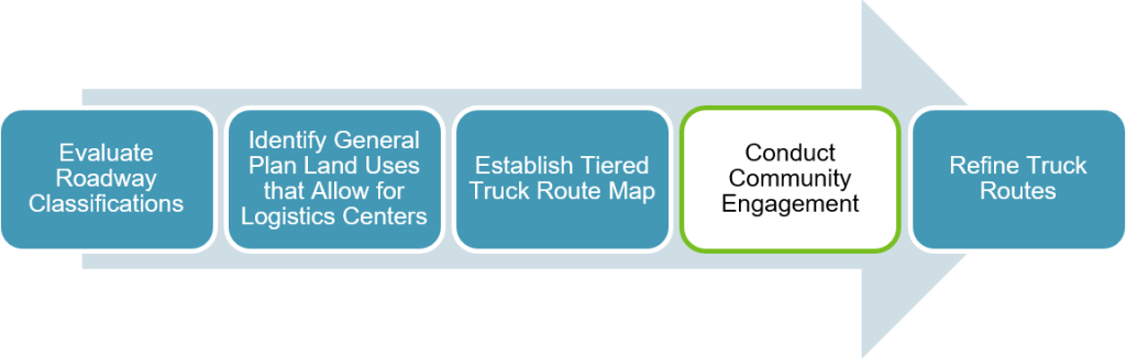
The County of Riverside is conducting a workshop on to discuss the requirements under Assembly Bill 98 (AB 98) and Senate Bill 415 (SB 415) to establish and designate a Countywide truck route system. The County is currently in the workshop phase, conducting outreach and community engagement. The level of environmental analysis for the Countywide truck routes is still being analyzed. View the below workflow to know what part of the process the County is currently at, outlined in green:
Meetings
| Date | Meeting | Location | Meeting Materials |
|---|---|---|---|
| 06/03/2026 | Community Workshop #1 (Planning Commission)
| Starts at: 9:00 A.M. County Administrative Center (CAC) 1st Floor Board Chambers 4080 Lemon St Riverside, CA 92501 | View the Workshop Notice (English and Spanish) |
| 07/29/2026 | Community Workshop #2 | Starts at: 6:00 P.M. Charles G. Meigs Community Center 21091 Rider Street Mead Valley, CA 92570 | View the Workshop Notice (English and Spanish) |
| 08/12/2026 | Temescal Valley Municipal Advisory Council (MAC) Meeting | Starts at: 6:30 P.M. The Terrace Club at Terramor 11750 Temescal Hills Drive Temescal Valley, CA 92883 | View the Temescal Valley MAC Website |
| 08/13/2026 | West Desert MAC Meeting | Starts at: 6:00 P.M. James A. Venable Community Center 50390 Carmen Avenue Cabazon, CA 92230 | View the West Desert MAC Website |

Interactive Truck Route Map
Below is the Geographical Information System (GIS) Interactive Truck Route map. If the map is not loading, visit this link: https://countyofriverside.maps.arcgis.com/apps/instant/basic/index.html?appid=08ed2643af3e4c809d8203399b9b76de
What are AB 98 and SB 415?
Assembly Bill 98 (AB 98, 2024) and Senate Bill 415 (SB 415, 2025) are California laws that establish statewide standards for warehouse and logistics developments. The laws were adopted to support the efficient movement of goods while helping reduce potential impacts from freight and warehouse operations on nearby homes, schools, parks, healthcare facilities, and other sensitive land uses.
SB 415 updated and clarified portions of AB 98, including terminology, roadway eligibility, implementation requirements, and compliance options available to local governments.
What does AB 98 and SB 415 require County of Riverside to do?
Riverside County is required to identify and adopt a designated truck route network and incorporate those routes into the County's transportation planning documents, including the General Plan Circulation Element. Because Riverside County is located within a State-designated Warehouse Concentration Region (WCR), the County was required to adopt designated truck routes by January 1, 2026. The County is making good faith effort to comply with the truck route requirement and regularly reporting progress to the California Attorney General’s Office.
The County is also updating related policies, maps, and implementation procedures to ensure consistency with State requirements governing truck circulation and warehouse development.
What is a Warehouse Concentration Region (WCR)?
A Warehouse Concentration Region (WCR) is an area identified by the State as having a significant concentration of warehouse, logistics, and freight-related activities. AB 98 identifies the WCR as the unincorporated areas in the Counties of Riverside and San Bernardino and the Cities of Jurupa Valley, Moreno Valley, Perris, Riverside, Chino, Colton, Fontana, Ontario, Rancho Cucamonga, Redlands, Rialto, and San Bernardino. The bill designates County of Riverside and portions of the Inland Empire as a WCR due to the importance of the region in California's goods movement network.
Jurisdictions located within a WCR are subject to specific truck route planning requirements established by State law.
What is a Truck Route?
A Truck Route establishes travel routes for the transport of goods, materials, or freight for storage, transfer, or redistribution to safely accommodate additional truck traffic.
Why is the County developing a Countywide Truck Route System?
The Riverside County previously updated its Board Policy F-3 (Good Neighbor Policy) in response to AB 98 to establish standards for warehouse and logistics development, including truck traffic, site design and land use compatibility.
To further implement AB 98 and SB 415, the County must identify and adopt designated truck routes throughout the unincorporated County. To meet these requirements, the County is developing a Countywide Truck Route System and evaluating related updates to the General Plan, Board Policy F-3, and other County regulations.
The County is seeking input from residents, businesses, public agencies, and other community members throughout this process.
What is a Sensitive Receptor?
Sensitive receptors are uses that include residences, schools, daycare facilities, publicly owned parks and recreation areas, playgrounds, recreational areas, nursing homes, and hospitals. AB 98 includes requirements intended to reduce potential impacts on sensitive receptors from certain warehouse and logistic developments, including requirements related to truck routes and location of certain logistic facilities.
How will this affect the surrounding communities?
AB 98 was adopted in response to the growth of warehouse and goods-movement industries throughout California. The law seeks to balance the efficient movement of goods with the health, safety, and quality of life of nearby communities. It includes standards intended to reduce potential impacts from truck traffic and improve compatibility between logistics uses and nearby homes, schools, parks, and hospitals.
To comply with State law, Riverside County initiated the Countywide Truck Route System in January 2026 and retained a consultant to assist with developing proposed truck routes and evaluating potential updates to County planning documents.
Potential environmental impacts, truck traffic patterns, and land use considerations associated with the proposed truck routes will be evaluated as part of the planning process. The County is also seeking input from residents, businesses, public agencies, and other stakeholders.
How does this affect the environment?
The County will review the proposed Countywide Truck Route System in accordance with the California Environmental Quality Act (CEQA). The type and extent of environmental review required will be determined as part of that process.
What types of destinations/land uses typically generate traffic?
Truck routes are intended to provide access between the regional transportation network and areas that generate significant truck traffic, such as industrial, warehouse, manufacturing, business park, and certain commercial uses.
In Riverside County, these destinations are generally located in areas planned for industrial, commercial, and business park uses under the General Plan and corresponding zoning classifications in Ordinance No. 348.
The purpose of designated truck routes is to direct truck traffic to appropriate roadways while minimizing impacts on residential neighborhoods and other sensitive land uses where feasible.
How will this change the General Plan?
Can trucks still drive on roads not designated Truck Routes?
Yes, truck routes are intended to direct truck traffic to preferred roadways whenever feasible. However, trucks may still use other roads when necessary to access businesses, residences, agricultural operations, construction sites, and other lawful destinations.
How are the Truck Routes chosen?
The County initiated the process in January 2026 to identify and designate Truck Routes. A consultant was selected to assist with the process of developing Truck Route maps and analyze the potential implications to the County General Plan. Geographic Information System (GIS) mapping tools are used to identify and evaluate potential truck routes based on the criteria below, including access to industrial and logistics areas and compatibility with nearby sensitive receptors:
- General Plan Land Use Element that allows for logistics centers.
- General Plan Circulation Element roadways.
- Land use and zoning GIS layers to determine the location of industrial related land uses and logistic access to major corridors.
- Location of Sensitive Receptor and sensitive land uses proximity to proposed routes.
- Existing truck traffic patterns.
- Caltrans Truck Network.
- Coachella Valley Association of Governments (CVAG) and Western Riverside Council of Governments (WRCOG) GIS data.
The County is evaluating routes that provide efficient truck access to industrial and logistics areas while minimizing potential impacts on nearby homes, schools, parks, and other sensitive land uses where feasible.
What is the proposed Countywide Truck Route System?
The County developed a tiered truck route network that aligns with Section 65302.02 of the Government Code. The three-tiered system includes:
Tier 1: State Facilities:
The Tier 1 truck routes were identified pursuant to the regulations specified in California Government Code § 65302.02(b), under which agencies shall:
- “Maximize the use of interstate or state divided highways as preferred routes for truck routes. The county or city shall also maximize use of arterial roads, major thoroughfares, and predominantly commercially oriented local streets when state or interstate highways are not utilized.”
Tier 2: Arterials and Collector Streets:
Tier 2 truck routes were identified pursuant to the regulations specified in California Government Code § 65302.02(b)(1), which states that:
- “Major or minor collector streets and roads that predominantly serve commercially oriented uses shall be used for truck routes only when strictly necessary to reach existing industrial zones.
Tier 3: Other Transportation Arteries:
Tier 3 truck routes were identified pursuant to the regulations specified in California Government Code § 65302.02(b)(2), which states that:
- “Trucks shall be routed via transportation arteries that minimize exposure to sensitive receptors.”
Will there be any signs for truck routes? Are any signs being removed?
Yes, signs are expected to be installed along designated truck routes to help direct truck traffic and identify truck routes, restrictions, and requirements. The County will also evaluate whether any existing signs need to be updated, relocated, or removed as part of the implementation process.
Are trucks able to park and idle on these routes?
No, trucks are only allowed to park and idle in designated facilities and logistic centers.
When and how would the truck routes be implemented?
The County of Riverside will amend the General Plan: Circulation Element, Good Neighbor Policy, and Ordinance 348 to include polices and restrictions for AB 98.
Truck Routes will be made publicly available in Geographic Information System (GIS) format on the Planning Department website and shared with warehouse operators, fleet operators, and truck drivers.
How are these Truck Routes being enforced?
The California Highway Patrol enforces truck routes on state highways and freeways. The County is currently evaluating implementation and enforcement procedures as part of the AB 98/SB 415 Logistics and Truck Routes process. Additional information regarding enforcement will be provided as the program moves forward.
Which Local Jurisdictions and Organizations is the County collaborating with?
The Riverside County has collaborated with Western Riverside Council of Governments (WRCOG), and Coachella Valley Association of Governments (CVAG). In the future, the County will be coordinating outreach to the District Supervisors, local Tribes, School Districts, Municipal Advisory Committees (MAC), Community Council Meetings, and adjacent City jurisdictions.
How can I stay informed or participate in the process?
Riverside County is seeking input throughout the AB 98 / SB 415 Logistics and Truck Routes process. Opportunities to participate include public workshops, Municipal Advisory Council (MAC) meetings, public hearings, and written comment periods.
Project updates, meeting information, and relevant documents will be posted on the project website as they become available.
Does the County currently have an established Truck Route Plan?
No, the County does not have a Truck Route Plan. The County utilizes Ordinance No. 500 that specifies weight limits, roads not suitable for trucks, and alternate roads.
Contact Us
John Hildebrand, Planning Director
Phone: (951) 955-3200
Email: [email protected]
Riverside Office
County Administrative Center
4080 Lemon St, 12th Floor,
Riverside, CA 92501