
Project Status
The Winchester Community Plan (WCP) project is expected to be completed in the second quarter of 2024. The project proposes an update to the General Plan and Harvest Valley/Winchester Area Plan, and will include an associated environmental impact report and design guidelines.
Following the County’s adoption of the updated plan, it is the County’s intention to process a program to update zoning within the plan area, where necessary, to ensure that all zoning within the plan’s boundaries is consistent with the plan’s amended General Plan Land Use designations.
The draft Environmental Impact Report (EIR) for the WCP was completed and circulated for a 45-day public review and comment period, from July 5, 2022 to August 19, 2022 (extended to September 23, 2022). Responses to comments received on the EIR are being prepared with an update to the nexus study which is in process.
Public hearings before the County’s Planning Commission and Board of Supervisors are expected to begin in the Spring of 2024, with final adoption of the plan by the County’s Board of Supervisors occurring in the Summer of 2024.
Project Characteristics
The proposed general plan amendment for Winchester (GPA No. 1207) would amend the Riverside County General Plan by:
- Expanding the Winchester Policy Area from approximately 287 acres to approximately 23,153 acres of land within the General Plan’s Harvest Valley/Winchester Area Plan.
- Amending the boundaries of the General Plan’s Harvest Valley/Winchester, Sun City/Menifee, and Southwest Area Plans so that the proposed Winchester Policy Area falls within the limits of the Harvest Valley/Winchester Area Plan only.
- Revising land use designations within the new Winchester PA, including Foundation Component amendments. Those land use changes that are not considered Foundation Component amendments would include changes from Rural Residential and Estate Density Residential to Low Density Residential, Medium Density Residential, Commercial Retail, Business Park, and Light Industrial. Approximately 227 parcels totaling 1,480 acres would require Foundation Component Amendments that include changes from the Rural and Rural Community components to the Community Development component. Consistency zoning revisions would occur in the future for approximately 921 parcels as a result of the revised land use designations proposed as part of the project and are analyzed as part of this EIR.
- Amending the the General Plan's Harvest Valley/Winchester Area Plan, Southwest Area Plan, San Jacinto Valley Area Plan, and Sun City/Menifee Area Plan to revise the existing Highway 79 Policy Area language by removing the 9% reduction density for residential projects. This policy will be replaced with a fee on newly entitled dwelling units (not dwelling units already entitled, to fund mobility related improvements, such as but not limited to, a vehicle park-n-ride and transit station within the Winchester downtown core area. These revisions to the Highway 79 Policy Area language will be carried throughout the General Plan document, where necessary for internal consistency. The Highway 79 Policy Area boundary includes approximately 50,061 acres. Additionally, revisions to several policies within the Area Plans to address the transition from level of service (LOS) to vehicle miles travelled (VMT) thresholds in environmental assessment such as this document.
The project also proposes the creation of new Design Guidelines for the Winchester Policy Area.
Winchester Notice of Availability and Completion for Environmental Impact Report
Winchester Community Plan Nexus Study
Winchester Community Plan Land Use Map
Click here for the interactive map
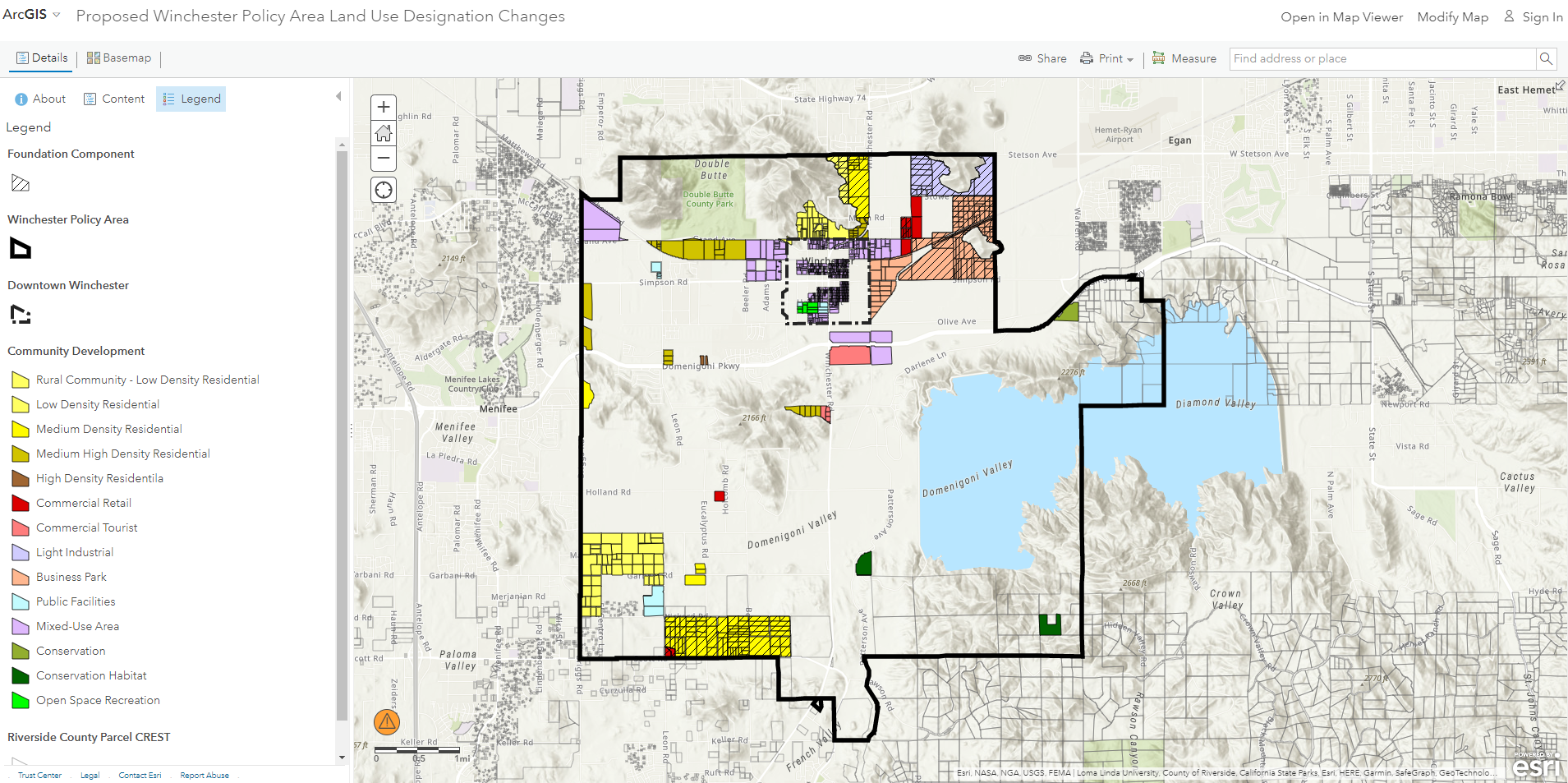
Winchester Policy Area Plan Boundary
Riverside County’s existing General Plan land use policies for most of the Winchester Community Plan area are articulated primarily through the Harvest Valley/Winchester Area Plan. The County’s existing General Plan land use policies for the southwestern portion of the community, specifically that area located between Briggs and Leon Roads, and between Newport and Scott Roads, are primarily articulated through the Sun City/Menifee Valley Area Plan. Both Area Plans were adopted in 2003, as part of the new countywide General Plan adopted at that time in conjunction with the Riverside County Integrated Project.
Several important planning studies and actions have taken place in recent years that have facilitated the proposed Winchester Community Plan, including the Winchester Land Use Study, the Riverside County 2021-2029 Housing Element (of the General Plan), and Caltrans’ Record of Decision regarding the preferred route of the Highway 79 realignment project,
The California Department of Transportation (Caltrans) concluded several years of studies and environmental reviews as it signed its Record of Decision establishing Highway 79 Realignment Project Alternative “1br” as its preferred alternative for the highway realignment project, as it moves forward. Project Alternative “1br” would realign and widen Highway 79 throughout the Community Plan area to a limited-access, four-lane expressway. This project would provide improved circulation and traffic capacity to accommodate growth in Winchester and surrounding communities.
Get involved! The Riverside County Planning Department is conducting periodic public meetings to inform the community about the status of this project and to receive public input.
Community Outreach
Initial Presentation only: February 9, 2017 - Project Introduction at the Winchester-Homeland Municipal Advisory Council (WHMAC) meeting.
Workshop No. 1: May 11, 2017 - Introduction, History, and Visioning at the WHMAC meeting.
Workshop No. 2: September 14, 2017 - Visioning at the WHMAC meeting.
Workshop No. 3: February 8, 2018 - Land Use Alternatives at the WHMAC meeting.
Workshop No. 4: October 11, 2018 - Draft Land Use Plan at WHMAC meeting.
Project Update: April 14, 2022 - PowerPoint Presentation at WHMAC Meeting.
Future community meetings: Notice will also be posted here in advance of each future community meeting.